A Detailed Project Report (DPR) is a comprehensive document that outlines the technical, financial, and operational aspect.
A land survey involves locating and measuring both man-made and natural objects using the basics of geometry, mathematics.
LiDAR – 3D Laser Scanning. SkyScan’s LiDAR solutions creates high-precision 3D models that measure elevation, volume and density,
the latest equipment and technologies to produce highly accurate pipeline surveys. Our expert staff determine the most suitable.
Geotechnical investigations are performed by geotechnical engineers or engineering geologists to obtain information
A Soil Stratification Survey, often referred to as a Soil Resistivity Survey, is a geophysical investigation used to assess the electrical.
A hydrogeological survey is a specialized investigation aimed at understanding the characteristics and behavior of groundwater.
Liquefied Natural Gas has become an important part of the global energy supply chain. Also, GOI proposes to increase the.
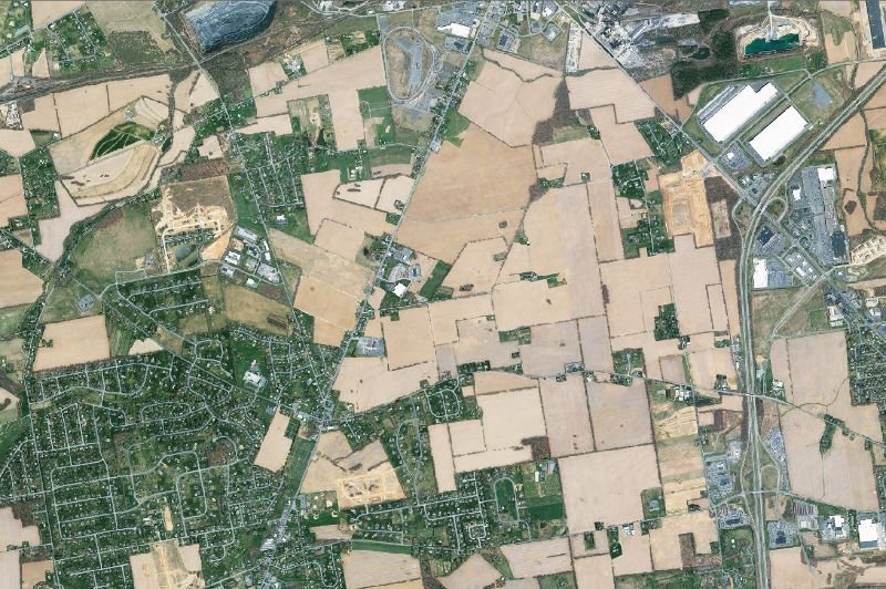
Satellite Image Processing is an important field in research and development and consists of the images of earth and satellites.
Valuable Geo-spatial information is contained in a wide variety of maps available in the form of images.
Property surveys for towns, villages, and cities are essential processes that involve the accurate measurement.
Detailed engineering drawings are an important part of product development, design, and manufacturing.
A branch of surveying, city survey implies an elaborate survey work of an area administered by an urban local body.
We provide complete range of services for photogeology, remote sensing, hyperspectral remote sensing data.
This guide details a method using computer vision techniques to automatically extract details from a set of scanned maps,
A detailed engineering survey is a comprehensive and precise process that involves the accurate measurement, analysis.
A corrosion survey is a specialized inspection and assessment process aimed at evaluating the extent and severity of corrosion.
A topographical survey, also known as a topographic survey, is a detailed and accurate representation.
A property survey is a sketch or map of a piece of land showing the property boundaries and physical features, like rivers, creeks.
Grid and contour surveys are two different surveying methods used to gather data and create detailed representations.
It is an accounting term used in the context of leasing arrangements, specifically under the International Financial Reporting Standards.
A Geographical Information system (GIS) is a tool, which can accept large volumes of spatial data derived .
Statutory clearances for pipelines refer to the regulatory approvals and permits required from various government authorities and agencie.
Manpower services for ROU (Right of Use) refer to the human resources and expertise required to manage and implement the leasing.


")

")


")